Survey Points Manager - Complete Introduction Guide
Comprehensive introduction to Survey Points Manager, the professional AutoCAD plugin for survey data management. Learn about features, installation, and getting started with real interface screenshots.
Survey Points Manager - Complete Introduction Guide
Professional AutoCAD Plugin for Survey Data Management
Survey Points Manager (SPM) is a comprehensive AutoCAD plugin designed specifically for surveyors, civil engineers, and CAD professionals who work with survey data. This powerful tool streamlines the process of importing, managing, and exporting survey points while providing advanced visualization and drawing capabilities.
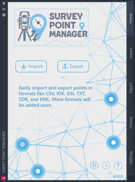 The Survey Points Manager Home interface serves as your command center, providing quick access to primary functions, recent operations overview, and direct navigation to specialized tabs.
What is Survey Points Manager?
Survey Points Manager is a professional-grade AutoCAD plugin that bridges the gap between field survey data and CAD drawings. Whether you're working with total station data, GPS coordinates, or field measurements, SPM provides the tools you need to efficiently manage large datasets and create professional drawings.
🎯 Interface Overview
Survey Points Manager provides a comprehensive, professional interface designed for surveyors and civil engineers. The plugin features a modern tabbed interface with five specialized sections, each optimized for specific workflows.
Main Interface Tabs
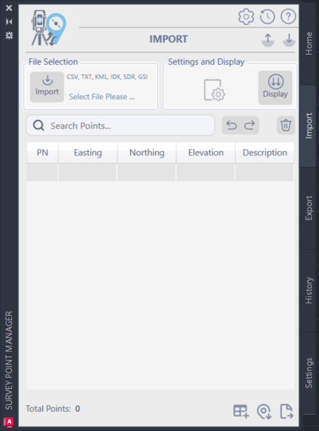
The Import tab is your gateway for bringing survey data into AutoCAD:
- Multi-format support with intelligent detection
- Format selection with visual feedback (bold for selected)
- File path display showing selected data source
- Settings panel for format-specific configuration
- Preview capabilities before final import
Key Capabilities
- Support for multiple file formats (CSV, TXT, KML, SDR, IDX, GSI)
- Automatic format detection and validation
- Batch processing for multiple files
- Real-time data preview and validation
- Interactive points grid with search and filter capabilities
- In-place editing with automatic validation
- Bulk operations for efficient data management
- Smart point numbering and organization
- Seamless integration with AutoCAD drawing environment
- Automatic point insertion with customizable styles
- Professional table generation for documentation
- Layer management and drawing organization

Who Should Use Survey Points Manager?
Surveyors
Land Surveyors: Manage boundary and topographic survey data Construction Surveyors: Handle site layout and as-built surveys Hydrographic Surveyors: Process bathymetric and coastal survey data
Civil Engineers
Site Design: Import survey data for design projects Infrastructure Projects: Manage large-scale survey datasets Quality Control: Validate and verify survey data accuracy
CAD Professionals
Drafting Technicians: Create professional survey drawings GIS Specialists: Convert between survey and GIS formats Project Managers: Coordinate survey data across teams

Version Selection Guide
Survey Points Manager automatically detects your AutoCAD version and loads the appropriate components. No manual version selection is required!
Automatic Version Detection
Latest AutoCAD (2025/2026)
- Uses .NET 8 version for optimal performance
- 25% faster processing than legacy versions
- Enhanced memory management
- Modern architecture with latest features

Installation Overview
System Requirements
- AutoCAD 2015 or later
- Windows 10 or later (64-bit recommended)
- 4 GB RAM minimum (8 GB recommended)
- 100 MB available disk space
- AutoCAD 2025/2026 with .NET 8 version
- Windows 11 (64-bit)
- 16 GB RAM or more
- SSD storage for faster file operations
Installation Process
- Download: Obtain the SPM installation bundle
- Extract: Unzip the installation files
- Install: Run the installer for your AutoCAD version
- Activate: Enter your license key when prompted
- Launch: Start AutoCAD and access SPM via the command line or ribbon

Interface Overview
Five-Tab Layout
Home Tab
- Points summary and statistics
- Quick actions (Clear All, Undo/Redo)
- Recent files access
- Status information and notifications

Getting Started Checklist
First-Time Setup
- ✓ Install SPM for your AutoCAD version
- ✓ Activate License using your license key
- ✓ Configure Settings according to your preferences
- ✓ Set Default Paths for import/export operations
- ✓ Test Import with a sample data file
Essential Skills to Learn
Data Import
Understanding file formats and import settings
Point Management
Using the points grid effectively
Drawing Integration
Inserting points into AutoCAD drawings
Export Operations
Saving data in various formats
Quality Control
Validating and verifying data accuracy

What's Next?
Now that you understand the basics of Survey Points Manager, explore these detailed guides:
- License & Activation Guide: Complete licensing information
- Import Data Guide: Master data import techniques
- Export Data Guide: Learn export options and formats
- Data Conversion Guide: Convert between formats efficiently
- History Management: Track and manage operations
- Settings Configuration: Optimize SPM for your workflow
Professional Support
As a licensed user, you have access to:
- Priority Email Support: 24-48 hour response time
- Video Training Library: Comprehensive tutorials
- Feature Requests: Influence future development
- Remote Assistance: Screen sharing support for complex issues
Survey Points Manager - Designed for surveyors, civil engineers, and CAD professionals
Ready to get started? Continue with the License & Activation Guide to activate your copy of Survey Points Manager.
How to Import Survey Data
Import CSV, TXT, GSI files into AutoCAD in 7 simple steps with screenshots.
Survey Points Manager - License & Activation Guide
Complete guide to licensing, activation, and license management for Survey Points Manager AutoCAD plugin. Learn about license types, activation process, and troubleshooting.
Leave a Comment